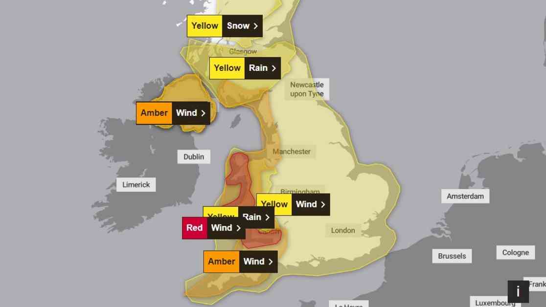
A severe red wind weather warning has been issued for parts of the UK, with gusts of 90mph expected. The Met Office has said “damaging winds” associated with Storm Darragh are expected to cause “significant disruption” as the weekend begins. Flying debris and fallen trees could pose a “danger to life” while large waves and beach material could be thrown on to coastal roads and seafronts. The warning covers coastal areas of Wales and the South West of England, including Cardiff, Bristol, and Devon, and is in place from 3 am to 11 am on Saturday.
Red weather warnings are the most serious type, and are only issued by forecasters when “dangerous weather” is expected. “It is very likely that there will be a risk to life, with substantial disruption to travel, energy supplies, and possibly widespread damage to property and infrastructure,” the Met Office website states. A separate red warning for wind has also been issued by the Irish meteorological service, Met Eireann. It covers coastal areas of Ireland including Mayo, Galway, Donegal, Leitrim, and Sligo and comes into force from Friday evening until early Saturday morning.
Storm Darragh, the fourth named storm of the season, has been fueled by a strong jet stream, directing extremely strong winds towards the UK and Ireland. Inland areas in the west will see gusts reaching 60 to 70mph over a long period of time, potentially more than 12 hours. Coastal regions will experience even stronger gusts, exceeding 90mph for areas within the red wind warning. The direction of the winds from the north or north-west instead of the prevailing south-west will expose typically more sheltered areas to higher risks.
Sunday will see the wind easing as Storm Darragh clears away, but it will still be quite windy in the south and east. Next week looks drier and calmer overall, with overnight frost and fog predicted. Gusts of 90 mph or more are possible over coasts and hills of west and south Wales, as well as funnelling through the Bristol Channel with some very large waves on exposed beaches. The strongest winds will begin to ease from late morning, though it will remain very windy with Amber wind warnings still in force until the evening.
Heavy Rain, Flooding, and Snow Expected
Two amber warnings for wind and a swathe of yellow warnings also remain in place, covering Northern Ireland, the west coast of England, Wales, and parts of Scotland on Saturday. Snow is expected in large parts of central Scotland, with a Met Office yellow weather warning in place from 8 pm Friday evening until 9 am on Saturday. Parts of Wales and Northern Ireland are also covered by rain warnings, with up to 90mm of rain expected overall, leading to potential flooding and disruptions.
Transport and Flood Alerts
Bus and train services are likely to be affected, and spray on the roads may make journey times longer. At the time of writing, seven flood warnings and 98 flood alerts had been issued by the Environment Agency for England, while six flood alerts were in place across Wales and 11 in Scotland.
In preparation for Storm Darragh, it is crucial to stay informed about the evolving weather conditions, follow safety advice, and take necessary precautions to ensure personal well-being and property safety. As the storm approaches, prioritize safety and adhere to official guidance to mitigate risks and minimize potential damages. Remember, your safety is the top priority during severe weather events like Storm Darragh. Stay safe and take care!


